4 October 2015
Well here we are again all excited about the next part of our adventure.
When we last talked Julie and I had just spent the past week or so enjoying Kinchega NP, Mungo NP and the National Parks of north-western Victoria, they being Hattah-Kulkyne, Murray-Sunset and its salt lakes and the sandy tracks in Wyperfield before finally ending up in Maryborough in the middle of Victoria. Remember all that - if you don't then obviously you only looked at the photographs and didn't read the words ... didn't you Amy!
As a bit of a recap - having achieved the bucket list of the things that I wanted to do with Burke and Wills and Cameron Corner, and with Julie being very pleased we did, we found ourselves at a crossroads. At the end of a really tough round of scissors-paper-rock we decided to go south through Victoria to follow the Great Ocean Road and to head west towards Kangaroo Island with the hope of getting on it.
 |
| Rounding up some sheep on the way to Apollo Bay |
With the big decisions behind us, after our stay in Maryborough, we had booked into Marengo Van Park just near Apollo Bay on the Great Ocean Road for four nights to explore the region. Friends we met on the Alaskan cruise a few months ago, Ken and Kathy, live nearby in Geelong so we invited them down for dinner and to watch the NRL grand final: Ken is an AFL fan so can't even spell NRL.
 |
| Lunch at West Barwon Reservoir, VIC |
4 October - NRL Grand Final Night - The weather was calm but cold. Despite that the four of us sat outside under the awning with the TV set up and the little fan heater at our feet and dined on silverside with veggies and some footy finals drinks. The more beer Ken had the more he understood rugby league. A great night was had by all. What a game!
 |
| A koala walking the Great Ocean Track |
Next day the four of us caught up again for breakfast and a day out. We did a walk along part of the Great Ocean Walk that leaves from our van park. The first thing we saw crossing our path was a koala - that's right a koala! The track is only 15 metres from the beach so, with not a gum tree in sight, of course we'd see a koala coming up from the surf beach and heading for the hills. Speaking of the surf, it was 6+ metres high and pounding the rocky coastline less than 120 metres from our caravan site.
 |
| Jeff, Ken, Kathy and Julie |
Lunch was held in the Apollo Bay Bakery, to try their curried scallop pies, which was followed by a drive then walk to Lake Elizabeth in Great Otway NP. On this track two snakes crossed our path which seems much more likely than a koala on the beach track. I still can't get over that. We said farewell to Ken and Kathy from here as they went home, as did we via Lorne. Kathy is still recovering from the shock of almost standing on one of the snakes - a large copper headed type one. Julie is still recovering from the ringing in her right ear from Kathy's shrieks!
6 October - another planning session was held this morning with all in attendance, they being Julie and I. The purpose of the meeting was to decide where we might go for the month of October. The minutes of the meeting will show that it was unanimously agreed to do the rest of the Great Ocean Road then continue to head west towards Adelaide but not go there. Instead we will head south and take the car and van over to Kangaroo Island for 9 nights. We will then return to the mainland and have another planning session to firstly ratify the minutes of today's meeting and then to decide what we will do next.
After the meeting was adjourned we had morning tea and discussed the weather. Geez I forgot to talk about the weather. As avid readers of this and earlier posts of the trip, you will recall that it has been very cold in the mornings and pleasant during the day. The same was true for our first day here in Marengo. Yesterday, when we spent the day with Ken and Kathy, the temperature rose to 34 degrees during the day and last night only went down to 21 degrees so for the first time this trip, all our windows were left open all night. This morning the temperature started to rise towards the early 30 degrees again but then the wind started to rise about 11am. I rolled up the awning due to the high winds (they topped out at 98 kph) before we headed out for the day. A cold front came through and the temperature had plummeted to 13 degrees by late afternoon. In Melbourne, when the front went through, their temperature fell 11 degrees in just 3 minutes. So what will I wear tomorrow? Having taken the doona off the bed last night, it quickly went back on for tonight.
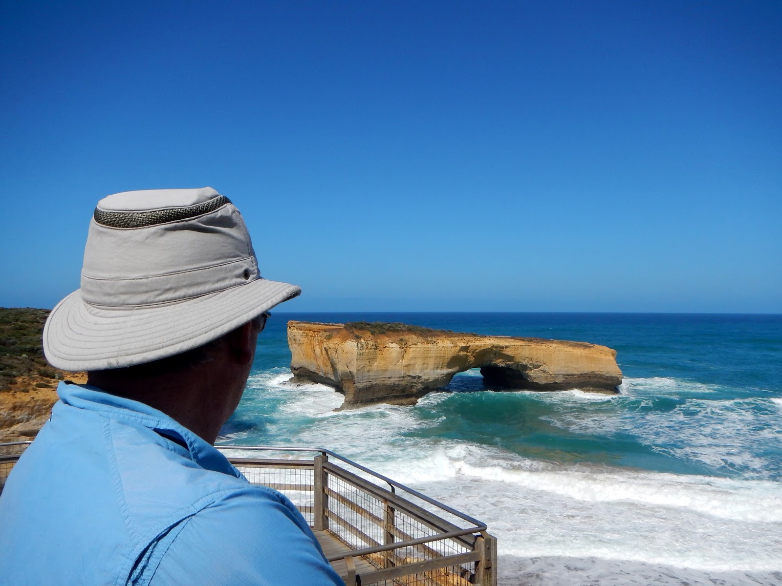
During all this crazy weather today we jumped in the car and headed west to drove the Great Ocean Road from our place having driven the eastern section yesterday. Stopping in at all the sights along the way we eventually stopped for lunch in Port Campbell. The number of tourists travelling the Great Ocean Road is huge.
 |
| Twelve Apostles |
 |
| Eileen at the 12 Apostles |
 |
| Two Apostles |
The Twelve Apostles was crazy with 100's of cars and buses stopped there. Around 70% of the visitors are from Asia. The track to the beach at Gibsons Steps was closed because of the high seas although looking down there didn't seem to be too much beach left.
 |
| Gibson's Steps |
 |
| RAAF flyover just for us |
Turning around we went down a couple of 4WD dirt tracks to our own private headlands to watch the massive swells pound the cliff faces to send spray well up and over them. If this wasn't enough to entertain us the RAAF flew four fighter jets just above the cliffs as we drove down one of the tracks. All-in-all another great day.
 |
| Swells hitting the 70 metres high cliffs |
7 October - today was yet another day to explore the Great Ocean Road, more for its walks and less for its iconic views. Armed with a trusty map we set off early and drove west again to explore Cape Otway. A walk around the Cape Otway Lighthouse and the 'lost' old cemetery - lost because we couldn't find it even though we followed the signs - reminded us that we had been here before several years ago.
We spied a dirt road heading off the bitumen road into Cape Otway and decided to head back there to see what we could see. On the way numerous cars were pulled over with their Asian occupants spilled out onto the road, cameras held at arm's length and, like frogs in a pond, they were happily going crick, crick, crick as they took photos of koalas resting in trees, at the base of trees about to climb, and in general star struck by all the attention. In fact, koalas are in plague proportions down here and are being culled as they are stipping the trees of vegetation and large areas of gums are dying off.
Anyway back to the dirt track that led to another then another until finally it led to a carpark. We walked down a track at the back of the carpark onto Point Franklin beach. Not another sole had set foot on it that day, not even a koala. With views to the lighthouse and over the deserted beach we found a rock and had something to eat and watched the huge waves pound the rocks in front of us.
 |
| Mait's Rest - great fern reception here |
 |
| Mait's Rest |
Next we drove further west to a much anticipated walk at Aire River which we could not find the start of no matter how hard we looked. So, heading back towards Apollo Bay, we pulled into Mait's Rest and did the most beautiful short walk. It led through a forest of fern trees that had set up camp here 100's of years ago beside a little babbling creek. Maitland Bryant, the District's first forestry patrol officer, used to stop and water his horses here in this serene area. Today a well formed path with boardwalks and interpretive signs take the interested walker along a beautiful rainforest loop walk. Just lovely.
Returning home we called into Apollo Bay to look at the local public art on the foreshore then back to camp for the afternoon to get ready for moving day tomorrow.
 |
| Port Campbell |
8 October - our target was Narrawong on the southwest Victorian coast, just a few kilometres short of Portland. The way to get here was via the Great Ocean Road. We left around 9am under sunny skies with light winds - just perfect. We drove past all the sights we had seen on our previous trips over the last couple of days and called into London Bridge, the Grotto, and the Bay of Martyrs.
 |
| London Bridge |
It was hard to take a bad picture at the Grotto which was well worth the short walk and stair climb down to view it.
 |
| The Grotto |
Next was Warrnambool which we stayed at when we went around Australia in 2013. It was here we had six hail storms in just one morning. The weather today was a lot calmer as we drove on to get to Narrawong around lunch time.
 |
| Our Narrawong campsite |
The campground at Narrawong was all but empty so we could pick any site we wanted - so we did. A walk along the beach out front of the our camp rounded off the day.
 |
| Petrified forest |
Just west of Portland are the petrified forest and blowholes. We spent the morning exploring these then went to Cape Nelson Lighthouse for lunch. This is a lovely region to visit and is on our 'to-come-back-to' list when we travel this way again.
 |
| A fan |
 |
| Moonscape of the Petrified forest |
 |
| Julie cooling off after a long day |
 |
| Clifftop walk - notice the cliffs |
 |
| Cape Nelson Lighthouse |
 |
| Jeff cooling off after a hot walk |
10 October - It is Saturday and we are booked on next Thursday's barge to Kangaroo Island so we have to push on in that direction with a couple of two night stops. Today we travelled into South Australia but before we entered we discovered they have some quarantine restrictions on basically everything fresh we have in the van. Just short of the border is the beautiful seaside village of Nelson. We pulled in here and found a lovely grassy spot right beside the water. We cooked up all the prohibited vegetables and what we didn't cook we ate for lunch while enjoying the view.
 |
| Nelson lunch stop |
With a Dream Pot full of cooking vegetables and stomachs bulging at the seams we entered South Australia all 'legal'. First came the signs that warn of quarantine restrictions, next the signs warning of on the spot fines and then a sign telling of disposal bins ahead and then there was .... nothing. No quarantine inspection point .... nothing. Anyway we know we did the right thing for South Australia and our country.
We arrived in the pretty town of Mt Gambier after lunch and checked into a quiet van park 2klm from the famous Blue Lake.
11 October - the weather remains cold with a minimum of 6 and a maximum of 16 degrees. The day was overcast but we were not deterred. To the Blue Lake we ventured.
 |
| A Blue Lake visit needs a blue jacket |
A walk around the edge of the 4600 year old volcanic crater that forms the lake started the day. Nearby is another lake - let's call it Brown Lake because it is. Brown Lake does have a Lions Club sponsored Conservation Park surrounded by electric fences. A stroll through this Park gave us the opportunity to see, up close and for the first time, an electric fence. It did come as a shock I have to say. There was little else to actually see but I'm sure what we didn't see was in dire need of conserving - and actually it's Valley Lake and we did see a historic windmill, one kangaroo, and quite a few birds.
 |
| Read the sign in the artistically taken photograph |
 |
| An historic windmill |
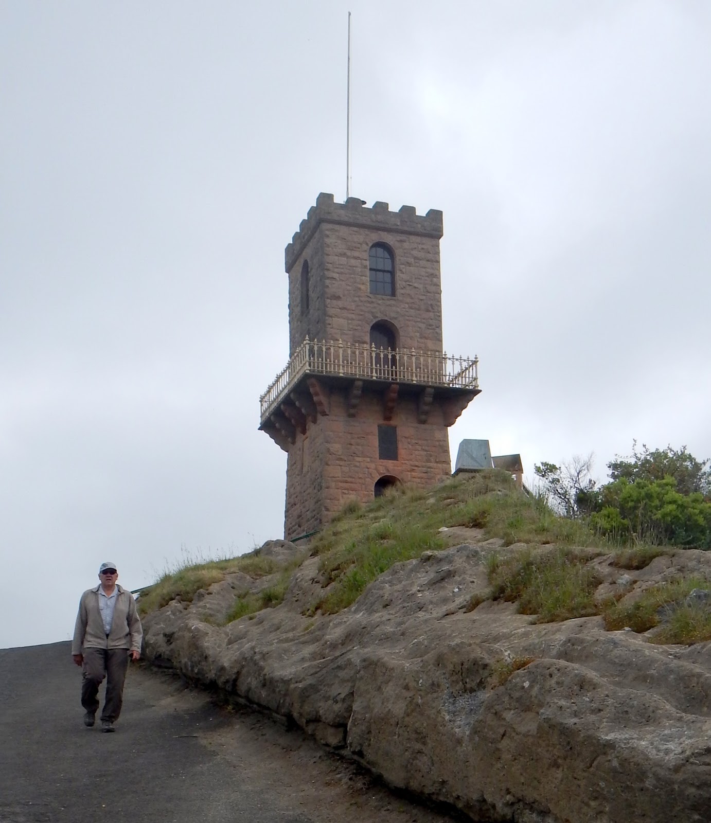
Next it was off to the Centenary Tower perched right at the very top of Mt Gambier at the very end of the steepest walking track you can imagine. We walked up here and we were so puffed as you can also imagine. At the top, if you can imagine this, there were spectacular views of the town and surrounding countryside all very reminiscent of England.
 |
| Conquered - the Centenary Tower in Mt Gambier |
 |
| Surrounding countryside of Mt Gambier from Centenary Tower walkway |
With still more things to do we dragged ourselves over to the famous Umpherston Sinkhole. Now this is something to see. In the middle of a beautiful lush park in the town of Mt Gambier is this sinkhole about the size of a large round hole in the ground.
 |
| Umpherston Sinkhole |
 |
| Umpherston Sinkhole |
Previously a farm owned by Mr Umpherston, today it is a stunning garden with long vines draping the walls and lovely manicured gardens at the bottom. For free, one can walk down, into and around the base of this sinkhole until your heart's content.
With contented hearts we ruined the feeling by doing the supermarket shuffle then headed home after quite a day of sightseeing. The day remained overcast which is the first totally overcast day we've had this trip so far. We were very pleasantly surprised by how much Mt Gambier has to offer with many walking and sightseeing options all beautifully done.
12 October - Moving Day - Off we went, staying as close to the coastal back roads as possible, heading west to Meningie. The drive was picturesque with nice spots for morning tea and lunch. Our morning tea spot was not in any book or map so I created it as a new location on Wikicamps called J&J Rest Stop. So if any of you are in the area, on the Southern Ports Highway, check it out and enjoy the views. We lunched at a rest stop in the Coorong NP overlooking a salt lake for which the area is known. We ended up at Lake Albert Caravan Park, Meningie with a wonderful outlook of, you guessed it, Lake Albert where we were fortunate to get a water side spot and settled in for an afternoon of bird watching.
 |
| Lake Meningie campsite |
 |
| Well trained puppy |
 |
| One birdy |
 |
| Two birdy |
 |
| Three birdy |
 |
| Pelican birdy |
 |
| No birdy |
Next day we set off with guide map in hand to do, what turned out to be, a 150klm loop drive in and around the Coorong. The drive was lovely taking us to many isolated viewpoints.
 |
| Waiting for a drink of water - Mark Point windmill & restored cattle trough |
 |
| Mark Point windmill & restored cattle trough |
 |
| Long Point, The Coorong |
 |
| Looking down on Narrung Ferry, "The Narrows" from Point Malcolm Lighthouse |

 |
| Track into Mark Point windmill & restored cattle trough |
 |
| The Art of Closing a Gate - see below |
The Art of Closing a Farm Gate, by Julie: As everyone knows the Passenger opens and closes farm gates while the driver drives through. In our travels over many years I have lost count as to how many gates my Passenger has opened and closed. The above photos hide a secret though. When closing the above gate my Passenger did something rather unique this time and unfortunately I was too slow to get a photo of it, but here she is coming back to the car. As she gets in she is a little red-faced and as soon as I said "I saw that" we both burst out laughing, my Passenger even more so.
My Passengers new technique is to close the gate with herself on the wrong side. Bahahaha!
 |
| Restored church at Raukkan - it's on our $50 note |
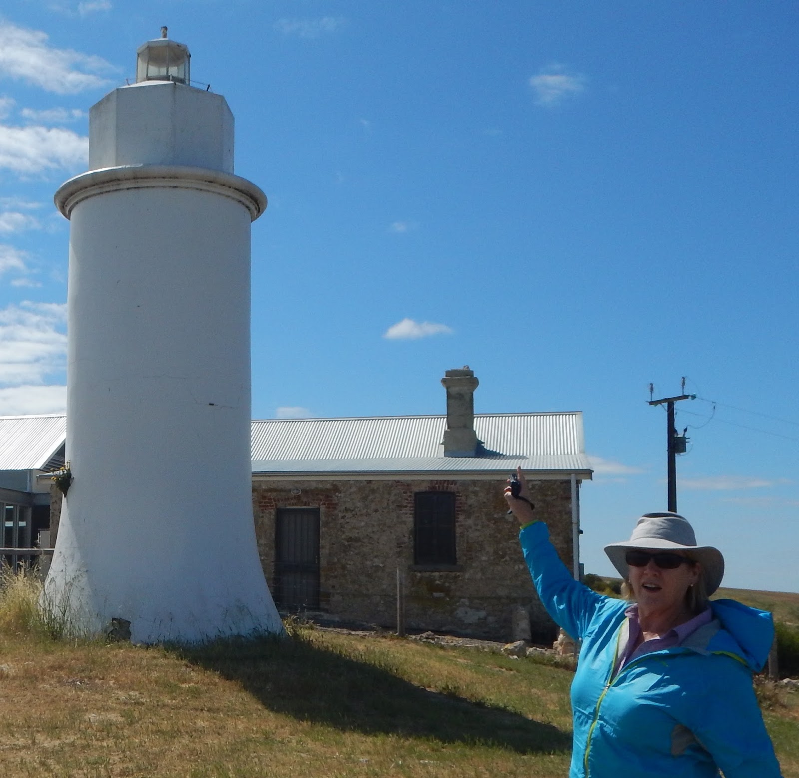
 |
| Point Malcolm Lighthouse - the only inland lighthouse in Australia |
We visited the indigenous township of Raukkan (formerly Point McLeay) and the restored Church that features on the $50 note along with a photo of an Aboriginal preacher/musician/orator/inventor/writer named David Unaipon who lived and is now buried in the area. Next we crossed "The Narrows" between Lake Albert and Lake Alexandrina on the (free) Narrung car ferry to Port Malcolm Lighthouse, Australia's only inland lighthouse. Birdlife was in abundance and we even spotted a Cape Barren Goose - the world's rarest geese. Well Julie thinks she spotted two others flying by however they were not - what a goose! After a quick photo stop at Pink Lake we stopped in at Meningie for a few local homemade relishes then headed home.
 |
| Pink Lady at Pink Lake |
The day started off overcast but just got better and better until we had clear skies and light winds from late morning. The afternoon was spent around camp getting everything ready for our trip to Kangaroo Island on Thursday. Late afternoon found us relaxing in our chairs in the warm sun right beside the lake watching the vast array of birdlife and moving closer and closer to the lake as the sun set and we sought out the warmest vantage points. We would certainly recommend Lake Albert Caravan Park, particularly if you can snag a lakeside site, and visiting Meningie and The Coorong.
 |
| Home after a hard day of sightseeing |
14 October - moving day. Today's target is a farmstay only a few kilometres from Cape Jervis. Tomorrow we catch the 9am barge to Kangaroo Island from Cape Jervis so we are after a nearby campsite.
On the way we came across the Murray River again and what better way than to celebrate with morning tea right beside it.
 |
| Murray River morning tea spot |
As we travelled south below Adelaide towards Jervis Bay the countryside became more and more undulating than we have been used to and at times even hilly. What better way than to celebrate this new found hilliness than to stop on top of one and have lunch. We chose Willunga Hill that overlooks the Gulf of St Vincent in the distance.
 |
| Willunga Hill, SA for lunch stop |
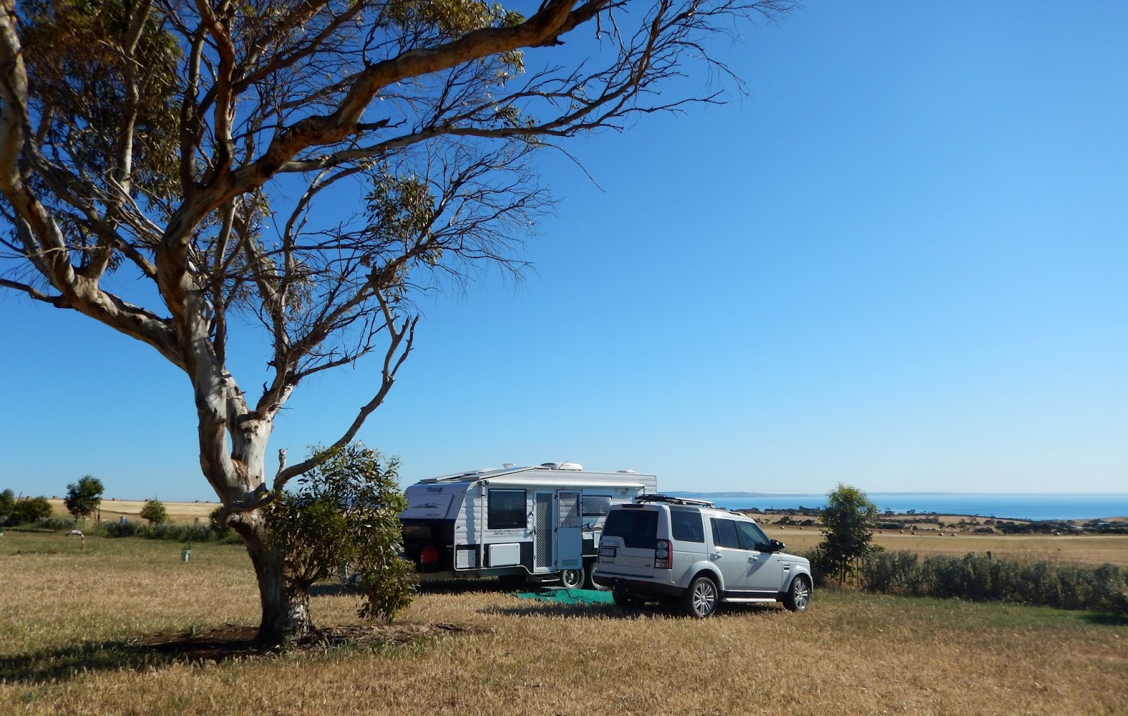
We arrived mid-afternoon at our planned camp just five minutes from Cape Jervis where the ferry leaves for Kangaroo Island (KI). It's a rather basic setup at the moment and is still a work-in-progress. In the next few years this now partly closed sheep station will provide a great stop for those travelling to and from KI. The views are spectacular and on a beautiful day like today is worthy of a night here.
 |
| Cape Jervis Station and CVP, SA - our site |
What better way than to celebrate these views than to end this Post right here, right now.
We, the car and the van are all travelling well. We hope you all are too.
Happy travels from the Grey Gonads
JeffnJulie


No comments:
Post a Comment